Department of Defense Community and Environmental Noise Primer
Noise and Compatible Use Zones Studies
The Military Services develop comprehensive noise studies to support communities, compatible land use planning, and DoD basing efforts by conducting detailed analysis of military activities, operations, and the sounds they produce. These studies use noise modeling software to account for all known activities and operations at the installation or range, as well as projected conditions which may affect or change sound levels throughout surrounding communities.
Noise studies are a comprehensive look at a community’s exposure to installation and range noise from current or future military activities. These studies produce maps that depict noise exposure levels (usually in DNL) that align with a common set of land use compatibility guidelines adopted by federal, state, and local governments. The studies recommend land uses for surrounding areas based on current and future military activities. Land use compatibility guidelines for noise provide agencies with the maximum recommended exposure for specific land uses and activities. For example, recommended maximum exposure levels for industrial land use are higher than recommended sound levels for residential areas or where schools and childcare facilities may be present.
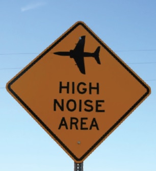
Naval Air Station Meridian partnered with Lauderdale County to post signs near areas exposed to higher levels of aircraft noise from nearby military training activity. Location of the signs were determined based on noise studies conducted at the installation. The signs have helped inform new home buyers, lessees, and realtors of areas that are exposed to higher levels of long-term aircraft noise exposure.
Naval Air Station Meridian partnered with Lauderdale County to post signs near areas exposed to higher levels of aircraft noise from nearby military training activity. Location of the signs were determined based on noise studies conducted at the installation. The signs have helped inform new home buyers, lessees, and realtors of areas that are exposed to higher levels of long-term aircraft noise exposure.
Naval Air Station Meridian partnered with Lauderdale County to post signs near areas exposed to higher levels of aircraft noise from nearby military training activity. Location of the signs were determined based on noise studies conducted at the installation. The signs have helped inform new home buyers, lessees, and realtors of areas that are exposed to higher levels of long-term aircraft noise exposure.
The noise study results and land use recommendations within noise studies are used to support planning, decision-making, and outreach for communities and DoD. These studies and noise management efforts help installation personnel provide information, recommendations, and assistance as communities develop and implement land use controls, such as zoning, special permits and projects, subdivision regulations, capital improvement programs, building codes, noise disclosure, establishment of easements, and public land acquisition. Working together, the military and its neighboring communities can prevent incompatible development around an installation, such as residential development in high noise zones or near installation boundaries.
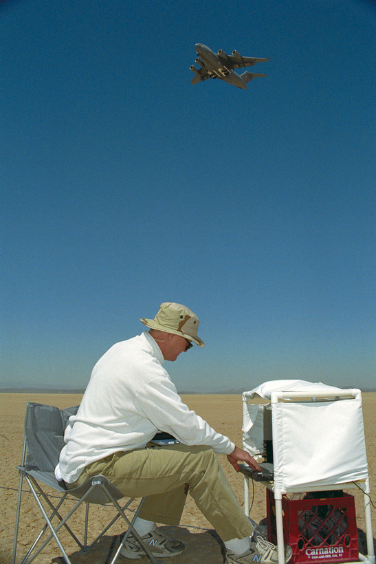
EDWARDS AIR FORCE BASE, Calif. — Eric Kurth, an engineering student from California Polytechnic State University at San Luis Obispo, Calif., sits on Rogers Dry Lake Bed here Sept. 10 to record the noise footprint of the C-17 Globemaster III, flying above, as it attempted various landing approaches on Edwards. Mr. Kurth was participating in a noise mitigation study being conducted by NASA with an Edwards C-17. (U.S. Air Force photo by Tom Tschida)
EDWARDS AIR FORCE BASE, Calif. — Eric Kurth, an engineering student from California Polytechnic State University at San Luis Obispo, Calif., sits on Rogers Dry Lake Bed here Sept. 10 to record the noise footprint of the C-17 Globemaster III, flying above, as it attempted various landing approaches on Edwards. Mr. Kurth was participating in a noise mitigation study being conducted by NASA with an Edwards C-17. (U.S. Air Force photo by Tom Tschida)
EDWARDS AIR FORCE BASE, Calif. — Eric Kurth, an engineering student from California Polytechnic State University at San Luis Obispo, Calif., sits on Rogers Dry Lake Bed here Sept. 10 to record the noise footprint of the C-17 Globemaster III, flying above, as it attempted various landing approaches on Edwards. Mr. Kurth was participating in a noise mitigation study being conducted by NASA with an Edwards C-17. (U.S. Air Force photo by Tom Tschida)
The military incorporates the results of noise studies in its noise reduction efforts, Joint Land Use Study (JLUS) Program, and other compatible land use programs including the including the Air Installations Compatible Use Zones (AICUZ) Program, the Navy Range Air Installations Compatible Use Zones (RAICUZ) Program, and the Marine Corps Range and Compatible Use Zones (RCUZ) Program. These programs promote outreach between installations and local communities that will help protect public health and safety, as well as preserve the operational utility of the installation. DoD also uses the results of noise studies to identify potential REPI projects and support funding decisions that prevent incompatible development around ranges and airfields. Noise studies are also used during strategic basing decisions and National Environmental Policy Act (NEPA) analysis.
Noise studies are developed using computer noise models to generate maps which depict noise exposure levels based upon existing or future military test and training activities. The levels plotted on the maps are then used to determine what types of land use would be compatible with the noise environment. Noise studies support military Compatible Use Zone programs, NEPA assessments, Joint Land Use Studies, and other planning initiatives. On the surface, noise studies can appear very complicated. Understanding how noise studies are developed and interpreted can help communities and the military make better land use planning decisions. This example of an Army noise study will walk through how the study was developed for Fort Benning and the information being conveyed in the maps.
Noise studies are developed using computer noise models to generate maps which depict noise exposure levels based upon existing or future military test and training activities. The levels plotted on the maps are then used to determine what types of land use would be compatible with the noise environment. Noise studies support military Compatible Use Zone programs, NEPA assessments, Joint Land Use Studies, and other planning initiatives. On the surface, noise studies can appear very complicated. Understanding how noise studies are developed and interpreted can help communities and the military make better land use planning decisions. This example of an Army noise study will walk through how the study was developed for Fort Benning and the information being conveyed in the maps.
Noise studies are developed using computer noise models to generate maps which depict noise exposure levels based upon existing or future military test and training activities. The levels plotted on the maps are then used to determine what types of land use would be compatible with the noise environment. Noise studies support military Compatible Use Zone programs, NEPA assessments, Joint Land Use Studies, and other planning initiatives. On the surface, noise studies can appear very complicated. Understanding how noise studies are developed and interpreted can help communities and the military make better land use planning decisions. This example of an Army noise study will walk through how the study was developed for Fort Benning and the information being conveyed in the maps.
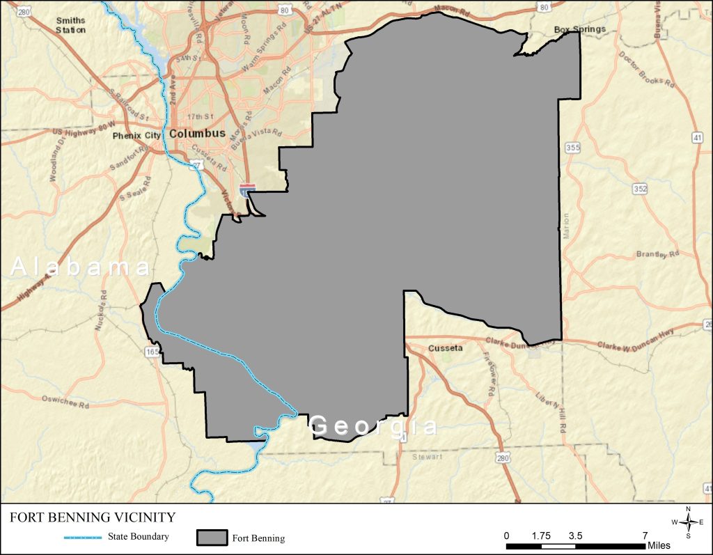
The Fort Benning Maneuver Center of Excellence is an approximately 182,000-acre Army facility located in western Georgia and eastern Alabama. The cities of Columbus, Georgia, and Phenix City, Alabama are located northwest of Fort Benning. Additionally, multiple small communities/towns are located adjacent to Fort Benning. The majority of the area surrounding Fort Benning is rural and undeveloped areas which primarily support farming, forestry and agricultural land uses.
The Fort Benning Maneuver Center of Excellence is an approximately 182,000-acre Army facility located in western Georgia and eastern Alabama. The cities of Columbus, Georgia, and Phenix City, Alabama are located northwest of Fort Benning. Additionally, multiple small communities/towns are located adjacent to Fort Benning. The majority of the area surrounding Fort Benning is rural and undeveloped areas which primarily support farming, forestry and agricultural land uses.
The Fort Benning Maneuver Center of Excellence is an approximately 182,000-acre Army facility located in western Georgia and eastern Alabama. The cities of Columbus, Georgia, and Phenix City, Alabama are located northwest of Fort Benning. Additionally, multiple small communities/towns are located adjacent to Fort Benning. The majority of the area surrounding Fort Benning is rural and undeveloped areas which primarily support farming, forestry and agricultural land uses.
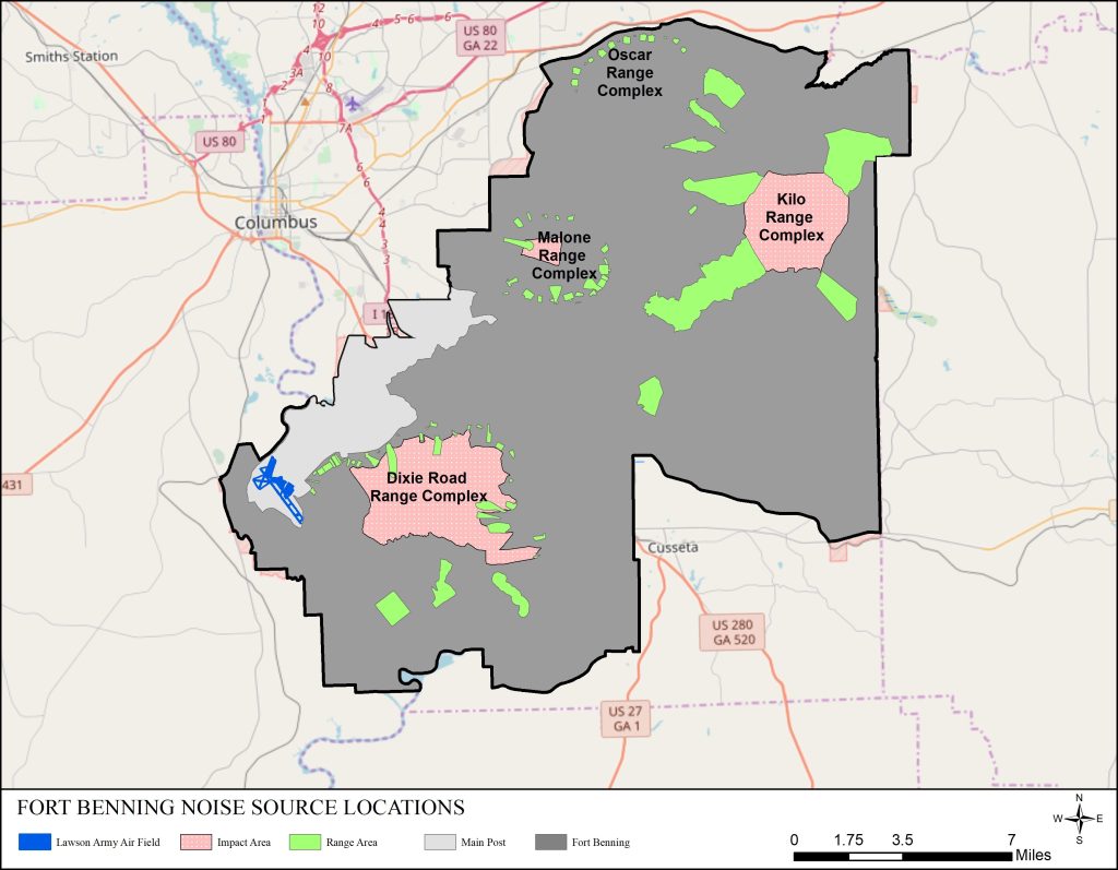
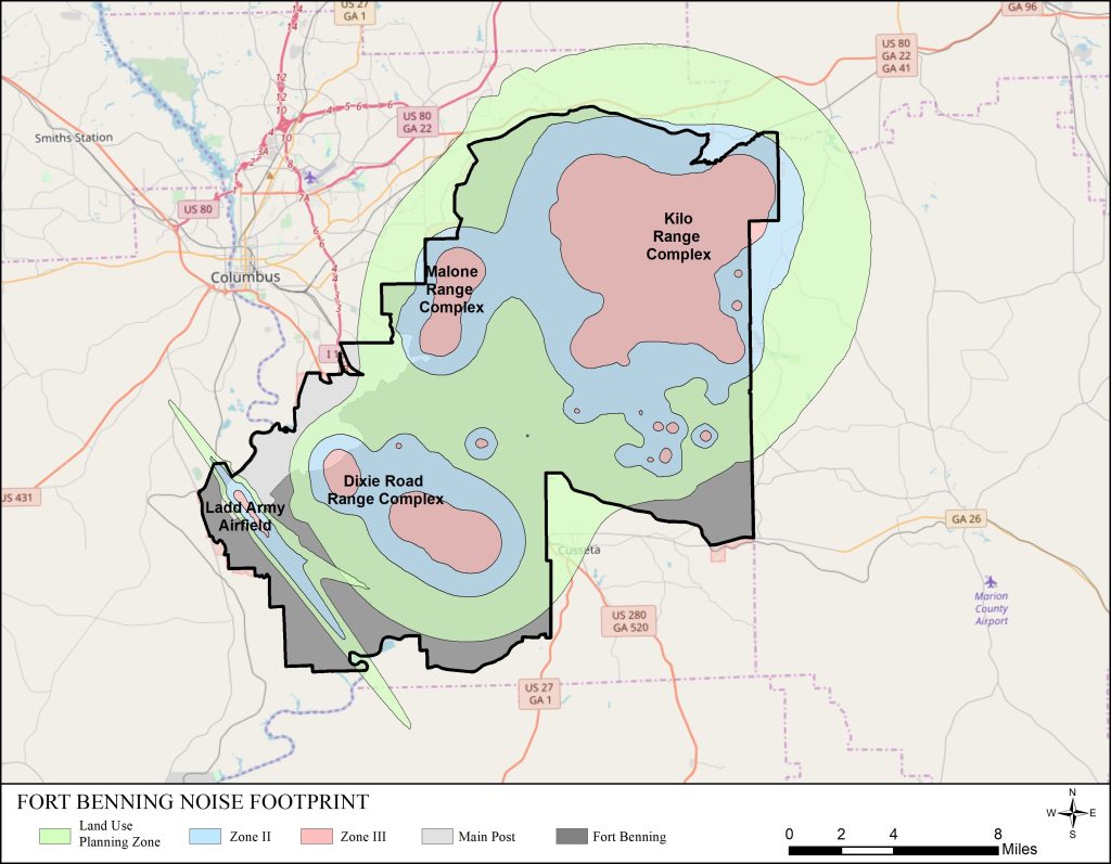
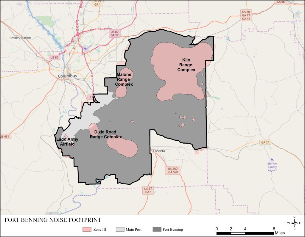
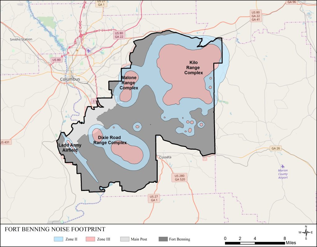
The primary noise source locations at Fort Benning are the weapon training ranges and facilities which are located in four areas on the range complex: Dixie Road Range Complex (adjacent to the cantonment area of Fort Benning), Kilo Range Complex (adjacent to the eastern boundary), Malone Range Complex (near the western boundary), Oscar Range Complex (adjacent to the northern boundary), and Lawson Army Airfield (at the eastern end of the cantonment area).
The primary noise source locations at Fort Benning are the weapon training ranges and facilities which are located in four areas on the range complex: Dixie Road Range Complex (adjacent to the cantonment area of Fort Benning), Kilo Range Complex (adjacent to the eastern boundary), Malone Range Complex (near the western boundary), Oscar Range Complex (adjacent to the northern boundary), and Lawson Army Airfield (at the eastern end of the cantonment area).
The primary noise source locations at Fort Benning are the weapon training ranges and facilities which are located in four areas on the range complex: Dixie Road Range Complex (adjacent to the cantonment area of Fort Benning), Kilo Range Complex (adjacent to the eastern boundary), Malone Range Complex (near the western boundary), Oscar Range Complex (adjacent to the northern boundary), and Lawson Army Airfield (at the eastern end of the cantonment area).
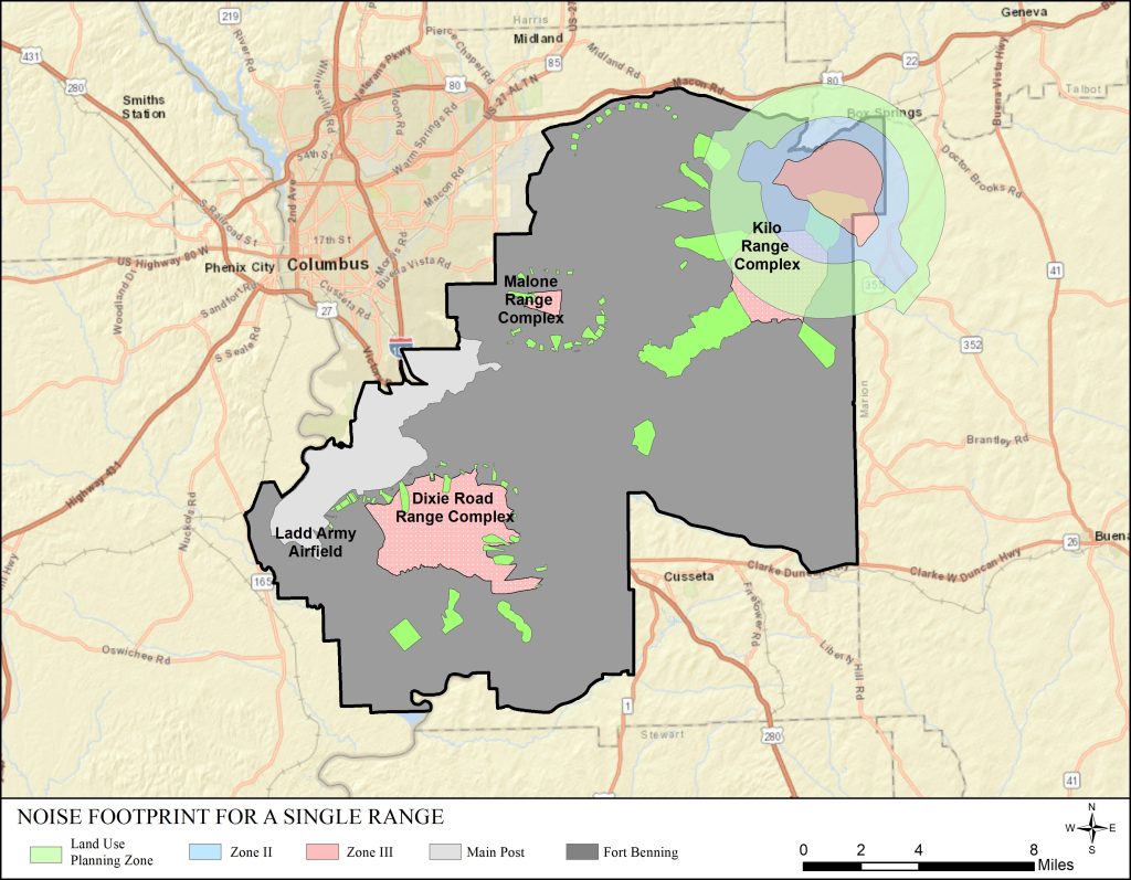
Noise studies address the cumulative noise environment, with each individual range/firing point/airfield contributing to the results. For simplicity, this example shows the extent of noise produced at the Kilo Range Complex, which includes a tank gunnery range for the M1 Abrams tank in the northeast corner of the installation. The contours represent noise exposure levels which are partitioned into “Noise Zones”. Zone III (red) is closest to the activity and represents the area of highest noise exposure. Zone II (blue) represents moderate noise exposure and the Land Use Planning Zone (LUPZ) shown in green is the outer contour. It should be noted that although the land outside of the Noise Zones would be described as compatible with noise-sensitive land use, military activities may at times be audible beyond the Noise Zones.
Noise studies address the cumulative noise environment, with each individual range/firing point/airfield contributing to the results. For simplicity, this example shows the extent of noise produced at the Kilo Range Complex, which includes a tank gunnery range for the M1 Abrams tank in the northeast corner of the installation. The contours represent noise exposure levels which are partitioned into “Noise Zones”. Zone III (red) is closest to the activity and represents the area of highest noise exposure. Zone II (blue) represents moderate noise exposure and the Land Use Planning Zone (LUPZ) shown in green is the outer contour. It should be noted that although the land outside of the Noise Zones would be described as compatible with noise-sensitive land use, military activities may at times be audible beyond the Noise Zones.
Noise studies address the cumulative noise environment, with each individual range/firing point/airfield contributing to the results. For simplicity, this example shows the extent of noise produced at the Kilo Range Complex, which includes a tank gunnery range for the M1 Abrams tank in the northeast corner of the installation. The contours represent noise exposure levels which are partitioned into “Noise Zones”. Zone III (red) is closest to the activity and represents the area of highest noise exposure. Zone II (blue) represents moderate noise exposure and the Land Use Planning Zone (LUPZ) shown in green is the outer contour. It should be noted that although the land outside of the Noise Zones would be described as compatible with noise-sensitive land use, military activities may at times be audible beyond the Noise Zones.
The noise models combine the noise at individual ranges to depict the cumulative noise exposure. The map does not represent a snapshot in time, rather it presents the annual average noise levels over the course of a year. This information then can be used to address land use compatibility.
The noise models combine the noise at individual ranges to depict the cumulative noise exposure. The map does not represent a snapshot in time, rather it presents the annual average noise levels over the course of a year. This information then can be used to address land use compatibility.
The noise models combine the noise at individual ranges to depict the cumulative noise exposure. The map does not represent a snapshot in time, rather it presents the annual average noise levels over the course of a year. This information then can be used to address land use compatibility.
Zone III is the area of highest noise exposure. Sound levels in Noise Zone II are greater than 75 ADNL or 70 CDNL. Noise-sensitive land uses (residential, schools, hospitals) are not compatible in these areas.
Zone III is the area of highest noise exposure. Sound levels in Noise Zone II are greater than 75 ADNL or 70 CDNL. Noise-sensitive land uses (residential, schools, hospitals) are not compatible in these areas.
Zone III is the area of highest noise exposure. Sound levels in Noise Zone II are greater than 75 ADNL or 70 CDNL. Noise-sensitive land uses (residential, schools, hospitals) are not compatible in these areas.
Sound levels in Noise Zone II are between 65 and 70 ADNL or 62 and 70 CDNL. Although local requirements for on- or off-base housing may require noise-sensitive land uses within Noise Zone II, such land use is generally not compatible within Noise Zone II.
Sound levels in Noise Zone II are between 65 and 70 ADNL or 62 and 70 CDNL. Although local requirements for on- or off-base housing may require noise-sensitive land uses within Noise Zone II, such land use is generally not compatible within Noise Zone II.
Sound levels in Noise Zone II are between 65 and 70 ADNL or 62 and 70 CDNL. Although local requirements for on- or off-base housing may require noise-sensitive land uses within Noise Zone II, such land use is generally not compatible within Noise Zone II.
The Land Use Planning Zone (LUPZ) is an area where sound levels are between 60 and 65 ADNL or 57 and 62 CDNL. Although noise-sensitive land uses are generally acceptable within the LUPZ, communities and individuals often have different views regarding acceptable or desirable levels of noise. To address this, some local governments have implemented land use planning measures beyond Zone II limits. Implementing such controls within the LUPZ can develop a buffer to prevent the possibility of future noise conflicts.
The Land Use Planning Zone (LUPZ) is an area where sound levels are between 60 and 65 ADNL or 57 and 62 CDNL. Although noise-sensitive land uses are generally acceptable within the LUPZ, communities and individuals often have different views regarding acceptable or desirable levels of noise. To address this, some local governments have implemented land use planning measures beyond Zone II limits. Implementing such controls within the LUPZ can develop a buffer to prevent the possibility of future noise conflicts.
The Land Use Planning Zone (LUPZ) is an area where sound levels are between 60 and 65 ADNL or 57 and 62 CDNL. Although noise-sensitive land uses are generally acceptable within the LUPZ, communities and individuals often have different views regarding acceptable or desirable levels of noise. To address this, some local governments have implemented land use planning measures beyond Zone II limits. Implementing such controls within the LUPZ can develop a buffer to prevent the possibility of future noise conflicts.
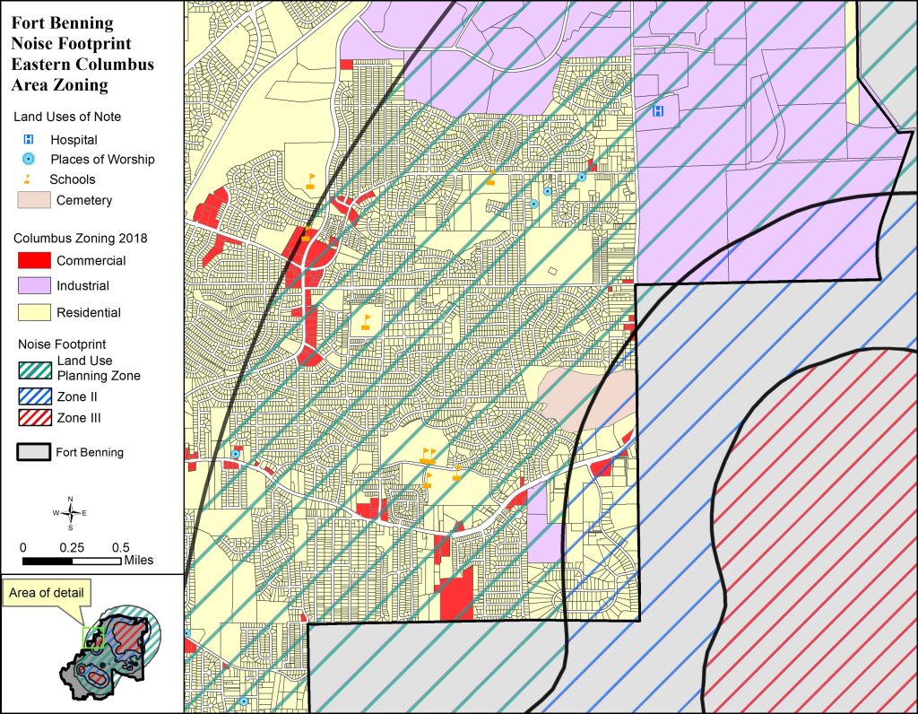
DoD compatibility programs encourage land use that is compatible with operations to protect the public health, safety and welfare. The maps shows that in this location, Noise Zone III is contained within FT Benning. Zone II does encompass some existing residential land use, but the good news is that it is at a lower density than within the LUPZ. Additionally, there is a large area of industrial zoning within the Zone II and LUPZ. Although much of the area is already built out, the goal of the installation would be to work with the community to ensure that the current industrial zoning would not be converted at any time to residential or another noise-sensitive use.
DoD compatibility programs encourage land use that is compatible with operations to protect the public health, safety and welfare. The maps shows that in this location, Noise Zone III is contained within FT Benning. Zone II does encompass some existing residential land use, but the good news is that it is at a lower density than within the LUPZ. Additionally, there is a large area of industrial zoning within the Zone II and LUPZ. Although much of the area is already built out, the goal of the installation would be to work with the community to ensure that the current industrial zoning would not be converted at any time to residential or another noise-sensitive use.
DoD compatibility programs encourage land use that is compatible with operations to protect the public health, safety and welfare. The maps shows that in this location, Noise Zone III is contained within FT Benning. Zone II does encompass some existing residential land use, but the good news is that it is at a lower density than within the LUPZ. Additionally, there is a large area of industrial zoning within the Zone II and LUPZ. Although much of the area is already built out, the goal of the installation would be to work with the community to ensure that the current industrial zoning would not be converted at any time to residential or another noise-sensitive use.